


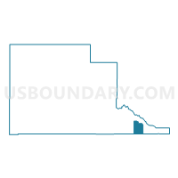
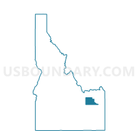
Clark Voting District, Jefferson County, Idaho
About
Outline

Summary
| Unique Area Identifier | 564122 |
| Name | Clark Voting District |
| County | Jefferson County |
| State | Idaho |
| Area (square miles) | 11.41 |
| Land Area (square miles) | 11.31 |
| Water Area (square miles) | 0.11 |
| % of Land Area | 99.06 |
| % of Water Area | 0.94 |
| Latitude of the Internal Point | 43.65517060 |
| Longtitude of the Internal Point | -111.83749230 |
Maps

Graphs
Select a template below for downloading or customizing gragh for Clark Voting District, Jefferson County, Idaho


Neighbors
Neighoring Voting District (by Name) Neighboring Voting District on the Map
- Voting District 019054, Bonneville County, ID
- Voting District 019059, Bonneville County, ID
- Labelle Voting District, Jefferson County, ID
- Rigby 3 Voting District, Jefferson County, ID
- Ririe Voting District, Jefferson County, ID
Top 10 Neighboring County Subdivision (by Population) Neighboring County Subdivision on the Map
- Rigby CCD, Jefferson County, ID (16,274)
- Ucon CCD, Bonneville County, ID (6,125)
- Ririe CCD, Jefferson County, ID (1,781)
Top 10 Neighboring Unified School District (by Population) Neighboring Unified School District on the Map
- Bonneville Joint School District 93, ID (45,322)
- Jefferson County Joint School District 251, ID (22,316)
- Ririe Joint School District 252, ID (2,557)